|
|
de Steensplinter — Geology and a cosmology of the obvious | 4.2 groundwork |
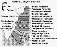 • geological section of the Grand Canyon (courtesy USGS). The directionality of time displayed in the succession of formations from below up to the top: (IIIb): wavy black lines indicate periods of non-deposition and erosion; another such line should have been drawn at (or above) the top (the present surface). (III): succession of Paleozoic layers from the Cambrian Tapeats Sandstone (540 my old) up to the Kaibab formation (250 my old); each successive formation younger than the one below it. (IIb): tilting of these sediments during a period of block-faulting or folding; (II): younger Precambrian (the Grand Canyon super group). (Ib): metamorphism of these rocks. (I): oldest pre-Cambrian (the Vishnu schist and Zoroaster Granite). previous (website version 2.30 - august 2007) |
groundwork [continued] 1. preview 2. geology, a key to the past 3. some evidence 4. formation of a bivalve shell 5. causality 6. inorganic processes geology, a key to the past When a geologist studies a landscape, he learns to see it as a four-dimensional object: mountains and valleys, rocks and sediments in the historical time-frame of how it all came about. And he will try to deduce the succession of past events and processes from the records they left in the shape, composition and structure of these rocks and sediments. This is illustrated on a grand scale by the Grand Canyon of Arizona (USA). The thick stack of still horizontally lying strata starts at the Indian Gardens, about 1500 meters below the rim, with Cambrian sand-stones and shales deposited some 540 million years (my) ago. The age of the Kaibab limestone at the rim is roughly 250 my old. Most of the layers were deposited just below or above sea level, except for the Coconino sandstone, the prominent white zone a short distance below the Kaibab formation. This Coconino sandstone was formed during a temporary withdrawal of the sea, causing emergence of the land into a windswept plain, that stretched over an enormous area. Some reptile tracks have been found in this sandstone, and fossil ferns and tetrapod tracks in the shales directly underlying it. What we see here is evidence of a total subsidence of 1500 meters during the entire Paleozoic accompanied by deposition of strata alternating with periods of erosion and non-deposition (wavy black lines). In contrast with this old (Paleozoic) subsidence the entire area of the Colorado plateau has in much younger time been uplifted to its present altitude. The Colorado and other rivers kept pace with this uplift, cutting ever deeper canyons. This is roughly how we read such records and what they can tell us about what happened in the past. They tell us what processes of sedimentation and erosion took place under what conditions of subsidence or uplift, submersion in the sea or emergence. The Colorado plateau is an exceptional area. Elsewhere there are all sorts of complications in the form of folding or thrusting, recrystallization and metamorphism. In a lowland area, on the other hand, there can be a total lack of sediment- or rock-outcrops. There the geologists probe the past by means of wells drilled to sufficient depths. continued |
| © 2007 - uitgeverij de Steensplinter - All rights reserved |